
Potentially catastrophic Tropical Cyclone Giri has struck Myanmar as a Category 4 storm.
As the eye of Giri reached the coast near midmorning, EDT, highest winds reached 140 to 145 mph, or high enough for extreme damage at the site of landfall.
The site of landfall was about 40 miles southeast of Sittwe (Akyab), or 250 miles northwest of Yangon, the Myanmar capital. It includes many coastal islands, some of them low-lying with many tidal channels, but also some high ground.
Storms of this intensity can raise storm surges 12 to 18 feet above normal tide.
Some consolation, however, may be that this storm was fairly small, with a relatively narrow swath of hurricane-force winds at the time of landfall.

Eye of Giri makes landfall in Myanmar as of 10/22/2010 (Credit: Navy Research Lab Monterrey).
Farming communities and small settlements are in the area of landfall, but not any major cities.
Headed for the Arakan Range, this storm will break up quickly inland, so the spread of its destructive winds will be confined to a small area. However, flooding rain, a serious threat from the coast to the mountains, could spill eastward to areas of interior central Myanmar through Saturday.
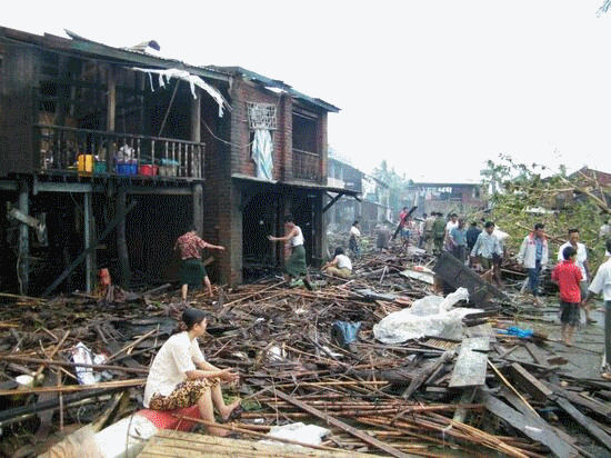
Myanmar has experienced major cyclone strikes in past. An extreme example would be Cyclone Nargis, which devastated the Irrawaddy River Delta in April 2008. Nargis killed at least 138,000 people, mostly by way of its high tidal surge, which spread over a wide swath of the flood-prone, populous Delta.
Myanmar is also known as Burma.
http://www.accuweather.com/blogs/news/story/40444/cyclone-giri-strikes-myanmar-w.asp
Cyclone Giri Photos
Cyclone Giri Strikes Myanmar with Devastating Force
Posted by
ေက်ာက္ၿဖဴသားေခ်
Tuesday, 26 October 2010
Powered by Blogger.


0 Responses to Cyclone Giri Strikes Myanmar with Devastating Force